Hike 1 - Mount Faber & Henderson Waves
 |
| Kelty FC3.0 |
Hike 2 - Bukit Timah Nature Reserve
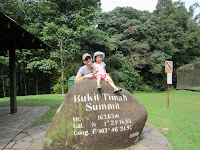
 Bukit Timah hill has the honor of being the highest point in Singapore. At 163.63 metres I am not sure it is anything to boast about, but we made it the target of our trek this week - we being Elizabeth, my work colleague and friend, Deepak, and myself. We couldn't find parking at he base of the hill, which is just as well as the parking lot was overrun by monkeys and I've learned my lesson in Thailand (see previous entry), so parked a bit further down. The park contains several paths for getting up and down the hill, but not knowing better we opted for the most obvious - a wide paved road that unabashedly makes its way straight up the steepest route. This road is so steep that people were walking down backwards to avoid injuring themselves. I was not prepared for the ascent and with Lizzy on my back I was out of breath about half-way, where we stopped to eat some bananas. I was completely spent by the time we made it to the summit (more bananas). We took the green-marked trail on the way back, which was much nicer, and we also detoured to the Catchment Path, which crosses the popular and challenging mountain bike trail going through this park. Lizzy managed to walk some of the way, and Deepak helped carry her most of the way back down. Aside from the greedy monkeys at the parking lot, we also spotted a pretty big snake resting on a branch.
Hike 3 - MacRitchie Reservoir -> Bukit Timah
Finally got Connie to join on a hike, and we were accompanied by the now-experienced sherpa, Deepak. The MacRitchie portion of this trail starts out at the MacRitchie Reservoir car park, meanders along the southern shores of he reservoir, passes through a hole or two of the Singapore Island Country Club golf course, crosses the Jelutong observation tower, and ends at Rifle Range Rd (there's no longer a rifle range). We met a family of aggressive monkeys here after I made the mistake of taking out an orange from my bag to snack on - do NOT feed, try not to make eye contact, and keep walking. We then reached the SingTel satellite station - bring aluminum foil to cover your head from radiation - where at least we had good cell phone reception. However, no cab company - we tried 2 - agreed to send a car there. Still not sure why. We then crossed the Bukit Timah Expressway and found our way to the Durian Loop (we only saw jackfruits). From there you have 2-3km to get to the base of Bukit Timah (around, not through, the hill). Deepak helped carry Lizzy about half of the way, and she walked about a half km or so on her own. This hike was slightly over 10km, but mostly over flat terrain, but about 3 hours into it Connie was ready to kill me. We made it through with no water to spare, and got a 10-min cab ride from Bukit Timah back to our car. Lunch at Crystal Jade in IMM - food always tastes better when you work hard for it!

No comments:
Post a Comment